ISRO recently shared stunning images from its CARTOSAT-3 satellite, revealing the aftermath of a powerful earthquake that rocked Myanmar on March 28. These earth-mapping shots snapped on March 29 over Mandalay and Sagaing paint a vivid picture of the destruction left behind.
Myanmar Quake: Satellite Pics Unveil Widespread Ruin

Source : ISRO
For a before-and-after look, ISRO compared these post-quake images with earlier ones taken on March 18 over the same spots. CARTOSAT-3, a cutting-edge satellite with sharp imaging skills, helped spot the changes and gauge the havoc.
“Downtown Mandalay took a big hit,” ISRO stated. “Places like Sky Villa, Phayani Pagoda, Mahamuni Pagoda, Ananda Pagoda, and the University of Mandalay saw heavy damage—some wrecked, others partially. Over in Sagaing, the Ma Shi Khana Pagoda and monasteries and buildings got battered too.”

Source : ISRO
The images also captured the dramatic fall of the historic Ava (InnWa) Bridge over the Irrawaddy River near Inn Wa City—it’s completely gone. Plus, cracks and ground splits along the river’s floodplains, with signs of soil turning mushy from the shaking.
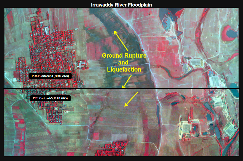
Source : ISRO
ISRO explained that a 7.7-magnitude quake hit Myanmar on March 28, followed by a hefty 6.4-magnitude aftershock. The epicentre sat at 22.013° N, 95.922° E, just 10 km deep near the Mandalay-Sagaing line.
The quake’s heart was close to Mandalay, Myanmar’s second-biggest city, which got slammed hard. The capital, Naypyidaw, and other areas felt it, too, with roads, homes, and structures crumbling under the strain.
“The shaking didn’t stop at Myanmar’s borders,” ISRO added. “It rippled out to places like Chiang Mai and northern Thailand, where folks reported damage from the tremors.”